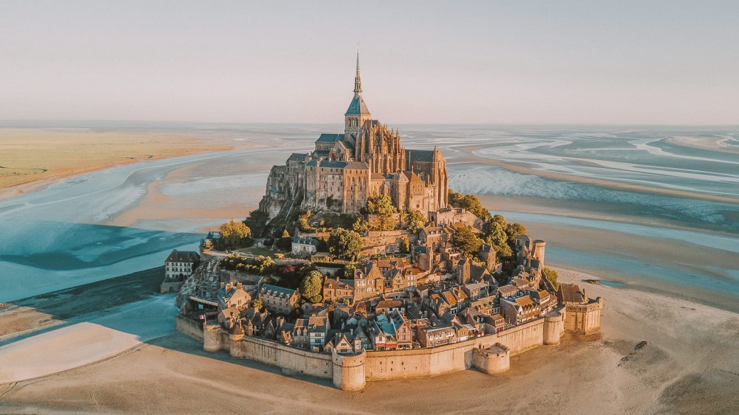
Mont Saint-Michel 聖米歇爾山

Le Mont-Saint-Michel (pronounced [mɔ̃ sɛ̃ mi.ʃɛl]; Norman: Mont Saint Miché, English: Saint Michael’s Mount) is an island and mainland commune in Normandy, France.
The island is located about one kilometer (0.6 miles) off the country’s northwestern coast, at the mouth of the Couesnon River near Avranches and is 7 hectares (17 acres) in area. The mainland part of the commune is 393 hectares (971 acres) in area so that the total surface of the commune is 400 hectares (988 acres).
As of 2015, the island has a population of 50.
The island has held strategic fortifications since ancient times and since the 8th century AD has been the seat of the monastery from which it draws its name. The structural composition of the town exemplifies the feudal society that constructed it: on top, God, the abbey and monastery; below, the great halls; then stores and housing; and at the bottom, outside the walls, houses for fishermen and farmers.
The commune’s position—on an island just a few hundred metres from land—made it accessible at low tide to the many pilgrims to its abbey, but defensible as an incoming tide stranded, drove off, or drowned would-be assailants. The Mont remained unconquered during the Hundred Years’ War; a small garrison fended off a full attack by the English in 1433. The reverse benefits of its natural defence were not lost on Louis XI, who turned the Mont into a prison. Thereafter the abbey began to be used regularly as a jail during the Ancien Régime.
One of France’s most recognisable landmarks, visited by more than 3 million people each year, the Mont Saint-Michel and its bay are on the UNESCO list of World Heritage Sites. Over 60 buildings within the commune are protected in France as monuments historiques.
Le Mont-Saint-Michel(發音為[mɔsɛmi.ʃɛl]; Norman:MontSaintMiché,英語:Saint Michael’s Mount)是法國諾曼底的一個島嶼和大陸公社。
該島位於該國西北海岸約1公里(0.6英里)處,位於阿夫朗什附近的Couesnon河口,面積為7公頃(17英畝)。該公社的大陸部分面積為393公頃(971英畝),因此該公社的總面積為400公頃(988英畝)。
截至2015年,該島人口為50。
自古以來,該島一直保持著戰略要塞,自公元8世紀以來,它一直是修道院的所在地,並以此命名。城鎮的結構構成體現了構建它的封建社會:最重要的是,上帝,修道院和修道院;下面,大廳;然後是商店和住房;在底部,牆外,漁民和農民的房屋。
公社的位置 – 在距離陸地幾百米的島嶼上 – 使得它可以在退潮時到達其修道院的許多朝聖者,但是當一股入境潮流擱淺,開車或被淹沒的潛在攻擊者時可以防禦。在百年戰爭期間,蒙特仍然未被征服; 1433年,英國一次小型駐軍擋住了英國人的全面攻擊。路易十一將自然防禦帶來的逆轉利益並沒有丟失,後者將蒙特爾變成了一座監獄。此後,修道院在AncienRégime期間開始被定期用作監獄。
法國最知名的地標之一,每年有超過300萬人參觀,聖米歇爾山及其海灣被列入聯合國教科文組織世界遺產名錄。公社內的60多座建築在法國受到保護,作為紀念碑的歷史。
Country:France
Region:Normandy
Department:Manche
Arrondissement:Avranches
Canton:Pontorson
Intercommunality:Pontorson – Le Mont-Saint-Michel
國家:法國
地區:諾曼底
部門:芒
郡:阿夫朗什
廣州:蓬托爾松
社區間:Pontorson – Le Mont-Saint-Michel
Abbey design
Plan of the mount by Eugène Viollet-le-Duc
In the 11th century, William of Volpiano, the Italian architect who had built Fécamp Abbey in Normandy, was chosen by Richard II, Duke of Normandy, to be the building contractor. He designed the Romanesque church of the abbey, daringly placing the transept crossing at the top of the mount. Many underground crypts and chapels had to be built to compensate for this weight; these formed the basis for the supportive upward structure that can be seen today. Today Mont Saint-Michel is seen as a building of Romanesque architecture.
Robert de Thorigny, a great supporter of Henry II of England (who was also Duke of Normandy), reinforced the structure of the buildings and built the main façade of the church in the 12th century. In 1204, Guy of Thouars, regent for the Duchess of Brittany, as vassal of the King of France, undertook a siege of the Mount. After having set fire to the village and having massacred the population, he was obliged to beat a retreat under the powerful walls of the abbey. Unfortunately, the fire which he himself lit extended to the buildings, and the roofs fell prey to the flames. Horrified by the cruelty and the exactions of his Breton ally, Philip Augustus offered Abbot Jordan a grant for the construction of a new Gothic architectural set which included the addition of the refectory and cloister.
Charles VI is credited with adding major fortifications to the abbey-mount, building towers, successive courtyards, and strengthening the ramparts.
修道院設計
EugèneViollet-le-Duc的山脈規劃
在11世紀,威廉的伏爾皮亞諾,意大利建築師,曾在諾曼底修建過FécampAbbey,被諾曼底公爵理查德二世選為建築承包商。他設計了修道院的羅馬式教堂,大膽地將橫斷面穿過山頂。必須建造許多地下墓穴和小教堂來彌補這個重量;這些構成了今天可以看到的支持向上結構的基礎。今天,聖米歇爾山被視為羅馬式建築的建築。
羅伯特·德·索里尼(Robert de Thorigny)是英格蘭亨利二世(也是諾曼底公爵)的偉大支持者,他在12世紀強化了建築的結構,並建造了教堂的主立面。在1204年,作為法國國王附庸的布列塔尼公爵夫人托馬斯的蓋伊進行了對山的圍攻。在放火燒毀村莊並屠殺人口之後,他不得不在修道院的強大城牆下擊退。不幸的是,他自己點燃的火焰延伸到了建築物,屋頂成了火焰的犧牲品。菲利普·奧古斯都為他的布列塔尼盟友的殘忍和侮辱而感到震驚,他為阿伯特·喬丹提供了建造新哥特式建築的資助,其中包括加入了食堂和修道院。
查理六世被稱為在修道院山,建築塔,連續庭院和加強城牆上增加了主要防禦工事。

History
The original site was founded by an Irish hermit, who gathered a following from the local community. Mont Saint-Michel was used in the sixth and seventh centuries as an Armorican stronghold of Gallo-Roman culture and power until it was ransacked by the Franks, thus ending the trans-channel culture that had stood since the departure of the Romans in 460. From roughly the fifth to the eighth century, Mont Saint-Michel belonged to the territory of Neustria and, in the early ninth century, was an important place in the marches of Neustria.
Before the construction of the first monastic establishment in the 8th century, the island was called Mont Tombe (Latin: tumba). According to a legend, the archangel Michael appeared in 708 to Aubert of Avranches, the bishop of Avranches, and instructed him to build a church on the rocky islet.
Unable to defend his kingdom against the assaults of the Vikings, the king of the Franks agreed to grant the Cotentin peninsula and the Avranchin, including Mont Saint-Michel traditionally linked to the city of Avranches, to the Bretons in the Treaty of Compiègne (867). This marked the beginning of a brief period of Breton possession of the Mont. In fact, these lands and Mont Saint-Michel were never really included in the duchy of Brittany and remained independent bishoprics from the newly created Breton archbishopric of Dol. When Rollo confirmed Franco as archbishop of Rouen, these traditional dependences of the Rouen archbishopric were retained in it.
The mount gained strategic significance again in 933 when William I Longsword annexed the Cotentin Peninsula from the weakened Duchy of Brittany. This made the mount definitively part of Normandy, and is depicted in the Bayeux Tapestry, which commemorates the 1066 Norman conquest of England. Harold Godwinson is pictured on the tapestry rescuing two Norman knights from the quicksand in the tidal flats during a battle with Conan II, Duke of Brittany. Norman ducal patronage financed the spectacular Norman architecture of the abbey in subsequent centuries.
Bayeux Tapestry scenes 16 and 17: William and Harold at Mont Saint-Michel (at top centre); Harold rescuing knights from quicksand
In 1067 the monastery of Mont Saint-Michel gave its support to William the Conqueror in his claim to the throne of England. This he rewarded with properties and grounds on the English side of the Channel, including a small island off the southwestern coast of Cornwall which was modelled after the Mount and became a Norman priory named St Michael’s Mount of Penzance.
Cannons abandoned by Thomas de Scales, 7th Baron Scales at Mont Saint-Michel on 17 June 1434. As of June 2013 only the second cannon, the one closer to the wall, is on display inside the entrance to the Mont’s outer wall.
During the Hundred Years’ War, the Kingdom of England made repeated assaults on the island but were unable to seize it due to the abbey’s improved fortifications. The English initially besieged the Mont in 1423–24, and then again in 1433–34 with English forces under the command of Thomas de Scales, 7th Baron Scales. Two wrought-iron bombards that Scales abandoned when he gave up his siege are still on site. They are known as les Michelettes. Mont Saint-Michel’s resolute resistance inspired the French, especially Joan of Arc.
When Louis XI of France founded the Order of Saint Michael in 1469, he intended that the abbey church of Mont Saint-Michel become the chapel for the Order, but because of its great distance from Paris, his intention could never be realised.
The wealth and influence of the abbey extended to many daughter foundations, including St. Michael’s Mount in Cornwall. However, its popularity and prestige as a centre of pilgrimage waned with the Reformation, and by the time of the French Revolution there were scarcely any monks in residence. The abbey was closed and converted into a prison, initially to hold clerical opponents of the republican regime. High-profile political prisoners followed, but by 1836, influential figures—including Victor Hugo—had launched a campaign to restore what was seen as a national architectural treasure. The prison was finally closed in 1863, and the mount was declared a historic monument in 1874. Mont Saint-Michel and its bay were added to the UNESCO list of World Heritage Sites in 1979, and it was listed with criteria such as cultural, historical, and architectural significance, as well as human-created and natural beauty.
歷史
最初的網站是由一位愛爾蘭隱士創立的,他從當地社區收集了一些人。聖米歇爾山在六世紀和七世紀被用作高層羅馬文化和權力的Armorican堡壘,直到被法蘭克人洗劫一空,從而結束了自460年羅馬人離開以來的跨渠道文化。從大約五世紀到八世紀,聖米歇爾山屬於奧地利領土,在九世紀初期,它是奧地利遊行的重要地方。
在8世紀建造第一座修道院之前,該島被稱為Mont Tombe(拉丁語:tumba)。根據一個傳說,大天使邁克爾出現在708到阿夫朗什主教阿夫朗什的奧貝特,並指示他在岩石小島上建造一座教堂。
弗蘭克斯國王無法為維京人的攻擊辯護他的王國,同意授予科唐坦半島和Avranchin,包括傳統上與阿夫朗什市相連的聖米歇爾山,以及Compiègne條約中的布列塔尼(867) )。這標誌著布列塔尼擁有蒙特的短暫時期的開始。事實上,這些土地和聖米歇爾山從未真正包含在布列塔尼公國中,並且仍然是新建的布列塔尼大主教Dol的獨立主教。當羅洛確認佛朗哥為魯昂大主教時,魯昂大主教的這些傳統依賴被保留在其中。
933年,當威廉一號長劍從布列塔尼公國的弱者中吞併科唐坦半島時,山脈又獲得了戰略意義。這使得山脈最終成為諾曼底的一部分,並在巴約掛毯中描繪,以紀念1066年諾曼征服英格蘭。 Harold Godwinson在與布列塔尼公爵柯南二世的戰鬥中,在潮汐平原上從流沙中救出兩名諾曼騎士的掛毯上的照片。諾曼公爵的讚助資助了後來幾個世紀修道院壯觀的諾曼式建築。
巴約掛毯場景16和17:威廉和哈羅德在聖米歇爾山(頂部中心);哈羅德從流沙中救出騎士
1067年,聖米歇爾山修道院在征服英格蘭王位時向征服者威廉提供了支持。他在英吉利海峽的英國一側獲得了財產和場地的獎勵,其中包括位於康沃爾西南海岸的一個小島嶼,該島嶼以山脈為藍本,成為名為聖邁克爾彭贊斯山的諾曼修道院。
1434年6月17日,聖米歇爾山第7男爵體育場托馬斯德斯卡萊斯遺棄的大砲。截至2013年6月,只有第二門大砲,靠近牆壁的大砲,在蒙特外牆入口處展出。
在百年戰爭期間,英國王國多次襲擊該島,但由於修道院改善了防禦工事而無法抓住它。英國人最初在1423年至24年間圍攻蒙特,然後在1433年至34年間,英國軍隊在7號男爵天秤座的托馬斯德斯卡萊斯的指揮下。當Scales放棄圍攻時,Scales放棄的兩枚鍛鐵轟炸仍在現場。他們被稱為les Michelettes。聖米歇爾山的堅決抵抗激發了法國人,特別是聖女貞德。
當法國的路易十一在1469年建立聖邁克爾勳章時,他打算將聖米歇爾山的修道院教堂成為勳章的教堂,但由於距離巴黎很遠,他的意圖永遠無法實現。
修道院的財富和影響擴展到許多女兒基金會,包括康沃爾郡的聖邁克爾山。然而,它作為朝聖中心的聲望和威望隨著宗教改革而減弱,到法國大革命時期,幾乎沒有任何僧侶居住。修道院被關閉並改建成監獄,最初是為了擔任共和政權的神職人員。隨後是備受矚目的政治犯,但到了1836年,包括維克多·雨果在內的有影響力的人物發起了一場恢復被視為國家建築瑰寶的活動。該監獄於1863年終於關閉,並於1874年宣布該山為歷史古蹟。聖米歇爾山及其海灣於1979年被列入聯合國教科文組織世界遺產名錄,並列入文化,歷史等標準。 ,具有建築意義,以及人類創造和自然美。


FROM:https://en.wikipedia.org/wiki/Mont-Saint-Michel
FROM:The Magical Mont-Saint-Michel: an Island once more at high tide
FROM:Mont Saint Michel from a drone.
Don’t you think it’s addictive?
Want to know more about the beauty of architecture?
Come and join our members to explore the beauty of architectural design.
覺得看得不過癮嗎?
想要知道更多建築之美嗎?
快來加入我們的會員,一同探索建築設計之美。
The above article is purely for appreciation and sharing purposes, as well as the construction of new technology and the public can be in-depth understanding of the information at the same time there are sources, will be able to query, no use of the document as a commercial transaction, if illegal, please inform the We will immediately remove the site, thank you for cooperation.
以上文章純粹作為欣賞及分享用途,以及將建築新型技術傳遞給與大眾能夠深入了解,同時資料還有來源,將可查詢,絕無使用該文件資料作為商業交易行為,如有違法請務必告知該網站我們將立即處理撤除,謝謝合作。

